The Easy
Campsite Search Method
for
Low Stress RV Boondocking
Do you get stressed out in your RV Boondocking campsite search every time you enter un-familiar territory?
Do you pull into new country you've never been in, and commence to drivin' 'round sweatin' nuggets and worryin' that you're not gonna find a place to pull your rig off the road 'fore it gets dark?
Well... Quit Doing That! There's just no need. There's a pretty simple solution that'll eliminate most of those nerve stretching difficulties.
These days, like as not, I've got my next RV boondocking campsite found before I even hitch up to pull out of our last camp!
There's two ways you can go about it.
The first is to head for a National Forest, BLM or Corp of Engineers developed campground in the area you want to stay in. You can find those on State maps, AAA maps, or the individual NF or BLM Website. I keep those bookmarked on my laptop.
You can Set up in one of those camps for a few days while you drive around the countryside doin' a wheels-on-the-ground campsite search. You'll be looking for the campsite for a long camp. Most areas allow you to occupy a camp for 14 days.
That method is still ok I guess... and it's how I did it for years. Now-a-days, I'm using technology to save me some dinero. With fuel at four dollars and more a gallon, driving up and down narrow tracks, hunting blindly for that good spot, can put a real dent in your RVing fuel budget.
To whittle a sharper point on that, wouldn't you also rather be doing the things you're traveling to that area to do, rather than spending days doin' a budget busting campsite search?
With modern technology, completing your next RV Boondocking Campsite Search... can be done sitting comfortable at your table in the early morning... while you're enjoying your morning coffee, still in your bathrobe! Yup... you can find several prospective options for your next camp while you're still sitting in your current camp.
There's a couple of bits of hardware you're gonna want to do the job. At the least, having them all in your possession is gonna make your task a lot easier, and even enjoyable.
Campsite Searching tools
*Lap Top Computer
*Individual National Forest Map
*Option to NF Maps is Delorme State Atlas & Gazetteers for each State traveled
*Google Earth/Google Maps loaded on your Laptop
*Road Map/Road Atlas
The Trail I follow to do my campsite search goes pretty much like this;
First, using the road map, I pick out the area I'd like to setup a camp in. A decent road map, especially the official state maps generally show you where National Forest is, many are even shaded for BLM.
The National Forest Maps for the areas of your search definitely show those National Forest and BLM lands, as well as state lands. My collection of NF maps is a valuable and growing asset.
Next, with the general area picked out, comes the special and fancy part of your campsite search. :) Fire up your laptop and pull up Google Earth or Google Maps... for this example I'm using the Google Maps.
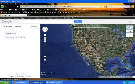
Select Satellite View... Now your campsite search will be looking at a recent photographic view of the land.
Now,
Zoom in to a paved road along your travel route. Zoom in closer to a
level that the small side roads and trails show up. Pan along the
highway till you see something turning off... and then change your
"Panning" to follow that trail.
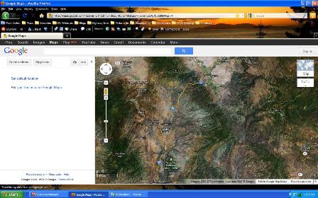
You'll zoom in close enough that you often spot other rigs that were staying there, or other vehicles present when that satellite photo was captured.
Not only that, the vegetation, or the lack of an overhead canopy, if like us, you're looking for solar power suitable RV boondocking campsites will be plain to see.
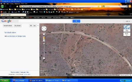
In the photo below you can see a NF road going off the picture at the top. Then, in the center of the screen capture, you see two dry creek beds running down below the dirt road... and to the right center a two track looping down below the road... That, is our campsite.
In the Google Maps program you can zoom in a lot closer than this... give it a try... pull it up and search some area you want to travel through. With a lil' practice and experience what your campsite search can find is pretty amazing.
When your campsite search finds a likely spot; a short trail branching off from the dirt road or the National Forest road, or even straight off the two lane... cross reference with your National Forest Map to verify ownership of the land. If it's National Forest or Bureau of Land Management (BLM). You may have just found your next camp.
The National Forest Maps have far more detail than any road map, to allow you to make a reliable decision about whose land it is. One option to using a National Forest Map are the detailed by state Delorme Atlases available. Those show minute details as well. At twenty bucks or so a piece, they ain't cheap, but probably will end up costing less, and taking up less space than a complete selection of National Forest maps, considering they've got the entire state inside.
The problem with only using the Satellite view is that you sometimes can't see the slope of the terrain clearly... But there's a solution for that too.
If you go back to the "Layers" icon or the Satellite/Map icon and select "Terrain" you'll get a new view showing elevation contour lines. If you've never used a Topo map before, the elevation lines show the rise or drop in elevation between the lines. Usually depending on scale those elevation changes are 10' to 20' or so.
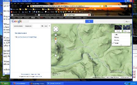
The closer those lines are together, the Steeper the terrain. The farther apart they are, the shallower the grade or, the more level the land is. In your campsite search you're looking for those places where the lines are the farthest apart. That's going to be the easiest place to set your camp.
In the program where you can blow it up larger than I can here, you'd see that those lines in this capture are widely spaced.
That view shows this camp... that I found sitting a hundred miles away, having my morning coffee...
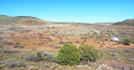
We made our drive, pulled in here with no worries, no sweating... and knowing dang near for sure and for certain that unless it was already occupied, we'd most likely have a good camp.
For that reason, the possibility of your prospective RV Boondocking campsite being occupied, it's a good idea to have lined out a few close by options.
With that satellite view in Google Earth, especially as you gain experience, you'll also be able to see from 17,000 miles in space, whether the trees and terrain are going to let a rig the size of yours roll in without difficulties.
It's not a bad idea to save that prospective site. It's pretty easy to mark and save a prospective campsite on either Googlemaps or Google Earth.
A few tips to hang on your campsite search.
1. Stop at National Forest District or Forest offices and buy one of their good forest maps. Setting yourself up a decent Mapcase to store the maps will serve you well.
2. When you search for a camp, don't simply break new trails into un-tracked meadows. A whole lot of folks have been acrossthis land before we got there, so there's no real shortage of tracks to follow. Keep to existing roads and tracks. Hunt for those and you'll save yourself a lot of grief with the local rangers. An hours campsite search, usually a lot less, on your laptop will have you sliding into soft camps in the early afternoon that you found before you started your motor! ;)
3. If you use a GPS system, either separate or the Navigation program on your smartphone, you can even plug in the co-ordinates and use it to guide you straight to your prospective campsite. Now... of course... always use that thing twixt your ears.
GPS systems are not foolproof or always correct. Their failings are legendary. They're a nice tool, but you have toemploy a mite of common sense to keep 'em honest.
If the GPS tells you to turn left onto a sidewalk... or to pull your 14' tall fifth wheel into a 7' high parking garage... Don't believe it! ;) Don't be one of the new stories started with; "But the GPS said turn here!" Your rig is not going to float well, simply because the GPS said turn into the canal.
4. When you do get to the site... DO NOT just blindly
drive on in. Do Pull off the road to where you can safely stop, then
climb on out and do an On Foot scout of the area. Make darn sure you can
safely drive in... and get back out again.
So, there it is. Simple as can be. The more you use it the better you'll
get. Pretty quick your experience will have you wandering into fresh
country without a worry about your campsite search or where you'll be
settin' up.
Take Care and Travel Far!
Return from Campsite Search to Goin' RV Boondocking


RV Boondocking Campsites
If your confidence is lacking to find your own genuine, full, RV Boondocking campsite, Do this.
Stay in one of the developed campgrounds. You're still boondocking. From there, make daytrips checking on Campsites using This campsite search method.
When your confidence has grown
sufficient, you can start going straight there rather than the short
stay in a paid, developed camp.
State Listings
- Alaska!!!
- NW
- NE
- SW
- SE
- Arizona
- NW
- NE
- SW
- SE
- California
- NW
- NE
- SW
- SE
- Colorado
- NW
- NE
- SW
- SE
- Idaho
- N
- CT
- SW SE
- Montana
- NW
- NE SW
- SE
- Nevada
- NW
- NE
- SW
- SE
- New Mexico
- NW
- NE
- SW
- SE
- Oregon
- NW
- NE
- SW
- SE
- Utah
- NW
- NE
- SW
- SE
- Washington
- NW
- NE
- SW
- SE
- Wyoming
- NW
- NE
- SW
- SE
Canadian Provincial Listings
- Alberta
- NW
- NE
- SW
- SE
- British Columbia
- NW
- NE
- SW
- SE
- Yukon
- NW
- NE
- SW
- SE
